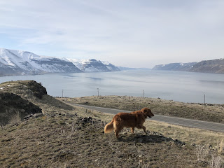
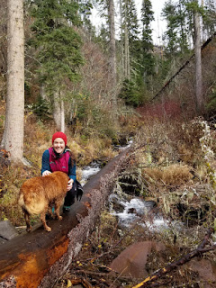
A few friends and I stumbled on this trail last year and I have been itching to get back to it. I decided to backpack in over night to avoid midday hiking and did 4 miles in and 4 miles out. Entered at Timothy Springs and slept at Trapper's Ridge.
This trail goes all the way to Troy (31 miles) but the reviews are sketchy at best... I think I'm going to get proficient at each of the ends of the trail and then maybe get the courage up to bushwhack my way through.
The trail is GORGEOUS: wooded and green for most of it. It follows the river all the way... sometimes over it on the cliff and sometimes along it in the flood zone. I don't think it's used very much: I was there Monday-Tuesday and was the only car and only human present. There were about 7 river crossings (I didn't actually count...) - 2 of which I swapped shoes from hiking shoes to chacos because it was fast and deep. There were countless downed trees along the trail... sometimes I went around them, sometimes over them, a few I crawled under (with my pack... it was classy). They kept me on my toes for sure. There are lots of parts of the trail that are padded down but have a great deal of overgrowth. Those areas are where I found tying survey tape to be very beneficial for my assurance that I could leave.
I definitely want to go back for more days/times... potentially with a handsaw or machete just to help the trail remain. If you're game for a sporty adventure, about 2 hours from home, this is definitely a hike for you - and let me know how it goes!
Necessary gear:
Survey tape (to find my way out)
Maps: USGS Jubilee, Bone Springs, and Wenaha Forks
Bear Bell (didn't see any but there was a significant amount of poo on the trail)
Gaiters
Water filter (because why carry a ton of water when you can filter it?)
Directions:
Drive to Tollgate... Left on Skyline (follow signs to Jubilee Lake).
At Jubilee, continue left (not FS-250 that takes you to the campground) to circumnavigate the lake.
Continue on NF-64 until the left turn to NF-019
After 2.1 miles on NF-019, take the right hand turn to NF-6415/Timothy Springs Road.
Continue on NF-6415 for about 3 miles until you see signs for Timothy Springs Campground (veryyyyy small). Turn left into the "campground", past the potty, and the trailhead is at the end of the road.
Walla Walla Outside
A resource for all things outside in the Walla Walla Valley. Send in your favorite things to do outside too!
Tuesday, July 21, 2020
Sunday, March 31, 2019
Seven Sisters Trailhead
I liked this trail so much I went twice in a row! It's a great place for kids and dogs to romp and to take in the views. It's less of a trail than an open space with opportunities for adventure: overlooks to climb, a sand pit for playing in, etc. It seems like it would be quite 🐍-y in the summer but great for spring an fall!
To get there, it's about 2.5ish miles after Wallula Junction on hwy 12. Go straight on to 730 at the junction and it's the second historical sign on your left. No permits necessary!
Wallula
Behind the historical sign, there's this highly informative trail sign!
We choose to do the north trail and tried to loop it, but I think a successful loop will require another try. The views were great though. A perfect spring hike!To get there, drive toward the tricities on highway 12. At the junction, go straight to Oregon. About 1.5 miles later, you'll see a historical sign on your left. Park there! No pass required.
Thursday, November 22, 2018
Tiger Ridge Trailhead
Driving up to Tiger Canyon to escape the fog, the dogs and I came across to gloriously happy signs: There is a trailhead that's marked before the Tiger Canyon gate and the Blues Crew trail team is showing it love!
Suspicious, the dogs and I went up Tiger for our usual ridge frolic. Coming back down, we stopped at the trail and decided to check it out.
The verdict was: The trail is awesome!
Well marked for about 30-40 minutes in, it has water spots, mowed meadow spots, and wooded spots. It's really clearly cut out (as of Nov 2018) and as it nears the spot of less cut out - the surveyor's tape marks the trail which is still really nice. The trail work suddenly ends, so I'm excited to see where it goes as they continue working on it. If you're looking for a nice hour or so stroll with water, grasses, and trees, this is the hike for you!
To get there: Drive east on Isaacs past Klickers, etc. Veer left on the road where it splits, keeping with Mill Creek Road. Then follow Mill Creek all the way past the Blue Creek turnoff, past where the pavement end, to where the road almost ends. Take the steep right turn down a steep mini-hill after all the cabins. Follow that road a bit to the first informative sign you see about Umatilla National Forest. Stop there and the trailhead is on your right!
Permits needed: I don't think any, but a NW Forest Pass never hurts!
Saturday, November 3, 2018
Falls by Tucannon
Out by Tucannon River Trail, there is another trail, marked before the bridge the marking is unusual - a large fallen log is carved in to say "Falls 1mi" just above eye level. Today, Susiedog and her intrepid humans adventured down this trail to the falls.
The trail is not marked but reasonably easy to follow Hiking it after a rainstorm led to high waters and slippery logs but it was still doable. The falls were beautiful and all humans and dog had a lovely time.
To get there: The road up is a bit bumpy. My Subaru Impreza made it, but not without a few frightful sounds. Directions: From Dayton, head east on Patit Road for 14 miles, turning left onto Hartsuck Grade and following it 4 miles to Tucannon River Road. Continue 13.2 miles south on Tucannon River Road (which becomes Forest Road 47) to a Y intersection. Bear left onto FR 4712 and follow this rough-at-times road 4.7 miles to its end and the trailhead (elev. 3550 ft). Privy available.
Permits needed: NW Forest Pass
Tuesday, September 18, 2018
Swegle Public Fishing Lands
Continuing our ongoing quest for new trails in and around Walla Walla, we went to the Swegle public fishing area off Swegle Road. It had about 2 miles of trails that are not very well maintained so all three of us on the trail got quite full of burrs. There were, however many great accesses to the river, including one near the parking area. If you need a quick swim and pretty river views, this is your place.
Directions: From Walla Walla, take highway 12 west toward Pasco. Take the exit for Heritage Road, turn right on Old Hwy 12. Turn left following signs for the Whitman Mission. Stay right and drive down Swegle. It is clearly marked after your second bridge that you drive over.
Permits needed: Discover Pass (Washington State Parks Pass)
Kayaking Palouse River Basin
I love paddling the Palouse but instead of putting my kayak in gear and powering through the basin, SusieDog and I decided to explore it, and it was beautiful. We stopped, hiked up and explored what appeared to be State Park land, and took in the views before paddling back to our put in.
Drive to Lyon's Ferry Marina, cross bridge to go to state park and after the main State Park entry, turn right to go to the secondary water access point. This helps you avoid having to go around the whole state park burm (important when you have a wiggly 50lb dog on your lap).
Permits needed: Discover Pass (Washington State Parks Pass)
Subscribe to:
Posts (Atom)